


Navigating Atlanta!
Your Guide to Getting Around Like a Native
By Muriel Vega
As a new resident, finding your way around Atlanta can be intimidating.
It’s a big place, after all, with different neighborhoods and landmarks spread out across a metropolitan area that stretches across several counties. In addition, there are four different interstates criss-crossing the city to keep track of. And of course, there are more than 70 streets with “Peachtree” in the name. To help you get your bearings, we’ve broken down some of the major streets, interstates and public transportation options you’ll need to know.MAIN ROADS AND HIGHWAYS
It all starts on Peachtree Street. Atlanta’s Main Street begins in the Five Points area of downtown, passing such landmarks as the Georgia-Pacific Tower and the Westin Peachtree Plaza Hotel before crossing northward into Midtown, where you’ll encounter the Margaret Mitchell House, the Woodruff Arts Center (home of the High Museum of Art), and the Fox Theatre. Just before passing Piedmont Hospital, it becomes Peachtree Road (specifically, at Palisades Road) before continuing on to the Buckhead district and Lenox Mall and Phipps Plaza. From there it’s on to Brookhaven, where it becomes Peachtree Boulevard before crossing I-285 to become Peachtree Industrial Boulevard.
Other prominent roads to know are West Peachtree Street, which runs parallel to Peachtree in downtown and Midtown; Ponce de Leon Avenue, which begins in Midtown and travels eastward to Decatur; and Buford Highway, the area’s center of international culture and cuisine, which is located primarily in DeKalb County to the northeast.
The Downtown Connector is the unofficial name of the approximately 7.5-mile stretch of highway where Interstates 75 and 85 merge as they pass through downtown Atlanta. Also known as 75/85, the Connector begins near Hartsfield-Jackson Atlanta International Airport at the Langford Parkway exit and runs north past the campuses of Georgia State University and later Georgia Tech. The Connector ends in Midtown, at an interchange known as the Brookwood Split.
The east side of the metro is served by Interstate 85. Heading south from the Connector, I-85 leads to East Point, College Park and the airport; its northward stretch passes Chamblee, Doraville, Duluth, and Suwanee on its way to the Carolinas.
Just past Suwanee, it branches off into Interstate 985, which leads to Buford, Flowery Branch, and Gainesville. After splitting with I-85, Interstate 75 heads northwest, climbing through Smyrna, Marietta, and Kennesaw on its way toward Chattanooga, Tennessee. Its southern stretch heads southeast toward Macon and eventually to Florida. Interstate 20, meanwhile, passes Six Flags Over Georgia on its way from Alabama into Atlanta, crossing the Connector and Interstate 285 on its way east.
Approximately 64 miles long, Interstate 285 is also known as “the Perimeter” because it forms a circle around the city. From East Point in the south, it travels north toward Smyrna, arcing east past Sandy Springs in the north (radio traffic reports usually refer to this section as “the top end”) and then south through Doraville, Tucker, and Stone Mountain, and then looping westward toward the airport and College Park. Two major landmarks along this route are the Cobb Cloverleaf, where 285 connects with I-75 northwest of the city, and the Tom Moreland Interchange, or “Spaghetti Junction,” where it intersects with I-85 near Tucker.
Georgia State Route 400, also known as Georgia 400, splits off from I-85 and cuts northward through Buckhead, Sandy Springs, Roswell, Alpharetta, and Cumming, after which it becomes a surface road near North Georgia Premium Outlets in Dawsonville. The major landmark along this road is the Concourse at Landmark Center, recognized for a pair of distinctive office towers known as the King and Queen buildings.
PUBLIC TRANSPORTATION
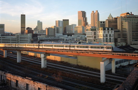
The Metropolitan Atlanta Rapid Transit Authority (MARTA) provides rail and bus service to the metro Atlanta area, with four rail lines operating primarily in Fulton and DeKalb counties. All four lines connect, offering transfers at the Five Points station located downtown off Peachtree Street. The one-way fare is $2.50 including transfers, and payment is easy with prepaid MARTA Breeze cards, which can be purchased at the train stations.
The Gold and Red lines travel a north-south trajectory, while the Blue and Green lines take an east-west route that runs mostly through the city of Atlanta. The Gold line goes from the airport through downtown and the business district, past Lenox Square Mall and Chamblee to end in Doraville. The Red line makes the same trek from the airport through the downtown area, but splits after the Lindbergh station and heads toward Buckhead and Dunwoody, ending near Sandy Springs.
The Blue line is the longest route, covering Avondale, Decatur, Candler Park, Inman Park, Grant Park, and Cabbagetown to the east. To the west, it stops at several landmarks, including CNN Center, Centennial Olympic Park, and the Georgia Dome. The Green line starts at Edgewood in the east and splits from the Blue line after the Vine City neighborhood, terminating in Bankhead to the west of the city.
To complement the rail service, MARTA offers bus and shuttle line. Bus stops are located throughout metro Atlanta with affordable fares and reliable schedules. MARTA also offers a free shuttle to Midtown’s Atlantic Station development and IKEA store, which departs from the Arts Center Station on the Red and Gold lines.
Other public transportation options include CobbLinc, providing bus service throughout Cobb County and to downtown Atlanta; Gwinnett County Transit, serving Gwinnett County with bus service to downtown, and the State Road and Tollway Authority, which operates the Xpress commuter bus service, offering 27 routes across 12 metro Atlanta counties.
Navigating Atlanta in your car can seem overwhelming. But now that you’re familiar with Atlanta’s major thoroughfares and transit options, you’re well on your way to getting around like a native. Bon voyage!
For more information
Georgia Department of Transportation | dot.ga.gov
MARTA | 404-848-5000, itsmarta.com
Cobblinc | 770-427-4444, cobblinc.com
Gwinnett County Transit | 770-822-5010, gctransit.com
Xpress | 844-977-7742, xpressga.com